
Landslides, flash floods and raging seas: is California ready for the ravages of El Niño?
A mix of natural disasters could all befall the state at once as it finds itself in the crosshairs of the climate phenomenon
On a cloudless autumn afternoon, sunlight sparkled on the water that had quietly swallowed a busy intersection to the north of San Francisco, as the surrounding rush-hour traffic slowed to a painful crawl.
There were no crashing waves or storm surges to blame for the flood. Marin county was one of many areas up and down the California coast affected by high tides last week, as parts of the Pacific swelled with excess warmth.
The submerged streets stood as an early signal of CaliforniaâÂÂs vulnerabilities as it braces for what could be a tumultuous winter.
âÂÂIf you think this is bad, just wait until December,â a state worker grumbled as he directed swarms of cars past the choke point toward a sidestreet.
Experts have warned that a potentially historic El Niño is brewing, with the power to unleash extreme weather around the world. The climate phenomenon, characterized by warmer than average equatorial sea surface temperatures, is already under way, according to federal forecasters, and it is expected to strengthen through the northern hemisphereâÂÂs autumn and winter.
California is poised to be in its crosshairs. Landslides, flash floods and encroaching sea levels are all on the menu â and they could all happen at once.

âÂÂWhat weâÂÂre really looking at is the compounding element,â Nick Brubaker, the chief resilience officer for the office of emergency management in Marin county said. The biggest concern isnâÂÂt just rising tides. ItâÂÂs the way everything could collide.
Dangerous spikes in temperature are likely. Some areas could see supercharged storms and relentless rains. Others face explosive surf, strong currents and devastated marine ecosystems. The effects of El Niño will add an additional foot of sea level rise in California on top of the 8in to 12in caused by the climate crisis there over the last century, according to Michael Anderson, a state climatologist.
And in recent wildfire burn scars, including the slopes of Big Sur that burned this summer and neighborhoods devastated by the 2025 firestorm in Los Angeles, there will be higher chances of debris flows.
The risks are but a taste of whatâÂÂs to come as the world warms. Preparations are already under way at all levels of government as officials work to secure vital infrastructure, preset response resources and inform the public of the incoming hazards.
âÂÂWe are trying to make sure that people are aware that this may be one of the most significant El Niño years that weâÂÂve seen,â Brubaker said.
Preparing for a hot fall and a wet winter
California stretches across roughly 770 miles (1,240km), and its regions are likely to experience El Niño very differently. Southern California typically sees wetter winters in El Niño years, but thatâÂÂs not necessarily the case further north.
While the stage may be set for violent weather, itâÂÂs impossible to forecast what will unfold. âÂÂWhat the science supports is elevated risk,â said Dr Ariel Cohen, a meteorologist for the National Weather Service, during a recent briefing held in Los Angeles. âÂÂA strong El Niño shifts the probabilities â it does not determine exact outcomes.âÂÂ
With the potential for dangerous conditions already rising, emergency managers are planning for the worst.
Gavin Newsom, CaliforniaâÂÂs governor, issued a state of emergency on 21 September to mobilize efforts and resources, kicking off a flurry of activity. Adverse conditions fueled by El Niño are already taking shape. A mass of warm water known as a âÂÂKelvinâ wave is crawling up the California coastline with the ability to raise sea levels by up to a foot.

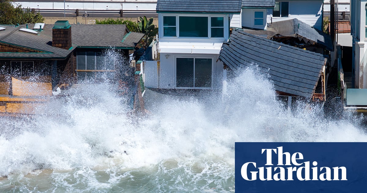
Along with coastal flooding from elevated sea levels and high tides, powerful storms swirling through the Pacific have made for an unusually busy tropical cyclone season. Hawaii is still recovering from a series of deluges and strong winds that flooded roads and buildings, unleashed landslides and toppled trees. Swathes of the southern California coastline were hammered by massive waves that damaged homes and devoured beaches.
Areas already hit hard are working to recover â and build resilience. In Long Beach, just south of Los Angeles, the seawall has been lined with large sandbags to reinforce spots where strong surf has burst through. In Orange county, roughly 690,000 cubic yards of sand is being pushed along the coastline. Workers are going door-to-door in San DiegoâÂÂs flood zones to help small businesses ready their buildings.
The Los Angeles county public works department has been assessing risks over the last six months, according to Mark Pestrella, its director, who said flood control systems are ready and optimized during a recent briefing.
Channels and debris have been cleared from drainages, 14 dams were tested and reservoirs prepared. These systems, he clarified, are designed to withstand a so-called âÂÂ100-year eventâÂÂ, which he said had a roughly 1% chance of occurring in any given year. But El Niño could bump those chances higher.
âÂÂWe are assuming it is going to rain and with El Niño we assume it is going to rain with high intensity,â Pestrella said.
Of particular concern, he added, were the areas still in recovery from the devastating wildfires that swept across LA county in January 2025, consuming more than 16,000 structures. In Pacific Palisades and Altadena, the communities that were most intensely affected, homes and buildings are still being rebuilt. Pestrella said it takes five years for watersheds and hillsides to heal enough to withstand strong rains.
Along LA countyâÂÂs 23 miles of coastline, large berms and sand dune systems are being built on beaches to fight against erosion, according to Gary Jones, the director of Beaches and Harbors. That effort happens every year, but officials are starting a month and a half earlier than usual.
âÂÂThis El Niño wonâÂÂt be the last one and unfortunately erosion at our beaches is becoming more and more common,â Jones said.
Meanwhile, LAâÂÂs office of emergency management director, Kevin McGowan, is juggling dangers on the other end of the hydrological spectrum: high heat and fire risks that are likely to linger into November.
âÂÂWe are in the middle of fire season and about to head into a significant heatwave,â McGowan said before a sweltering October weekend that smashed several records across southern California, noting that fire conditions can still peak through the winter months. âÂÂPeople should continue to prepare not just for one hazard â but all hazards.âÂÂ
âÂÂThe sandbags are readyâÂÂ
For Mary Ellen Carroll, the executive director of the San Francisco department of emergency management, the good news is there is still time to prepare.
âÂÂIt feels like IâÂÂm planning for an earthquake, but IâÂÂve gotten two monthsâ notice,â she said.
Along with elevated flood risks around the port and the Embarcadero on the Bay side, and dangerous ocean conditions along the beaches, there could be long power outages during storms. For people that are more vulnerable â older people and folks that are medically dependent â âÂÂit can get very dangerous quicklyâÂÂ, she said.
While El Niño doesnâÂÂt as directly produce more moisture-laden storms in this part of the state, elevated sea levels will continue to be a concern. Record high-tides are likely between December and February next year. California king tides â when surf is highest â will occur during the week of Thanksgiving, the week of Christmas, and on the Martin Luther King Jr long weekend, making for a potentially dangerous holiday season.

Back in Marin, where low-lying areas flood even without the added influence from El Niño, Brubaker said the county was rushing to clear drains and culverts, and installing temporary flood barriers.
They have also expanded their supplies of free pre-filled sandbags and generated detailed online interactives so residents and visitors can more easily visualize their risks.
About 70 miles south, in the beachside tourist town of Santa Cruz, the emergency services manager, Meredith Albert, said this yearâÂÂs preparations fall in line with the challenges coastal communities have long faced. âÂÂWe are building on what we all know have been our risks and hazards all along â for better or worse, they arenâÂÂt a surprise,â she said of the atmospheric river events, coastal erosion and flooding that can wreak havoc in any year.
Santa Cruz has seen its fair share of extreme weather. In 2024, a parade of storms and violent surf knocked out the cityâÂÂs beloved pier, which only recently reopened.
While thereâÂÂs careful consideration of overstating messages and emergency alert fatigue, Albert added that âÂÂthe public messaging is ready to go. The sandbags are ready.âÂÂ
But the biggest priority is to ensure preparedness starts at individual and neighborhood levels âÂÂand grows outward from thereâÂÂ, Albert said. In Santa Cruz, they have planned neighborhood workshops where city staff will meet with small groups to discuss the dangers, what the city will be able to do and how people can help one another.
The goal is not to make Santa Cruz invulnerable. But building resilience in communities will be the key to navigating the uncertainties of when and how calamity could strike.
âÂÂThose community connections are the difference between a disaster being something you canâÂÂt come back from and something you can learn from.âÂÂ
ItâÂÂs a sentiment being echoed across the state.
âÂÂWe are never going to have enough resources at the onset of a disaster to support every single person,â McGowan cautioned in Los Angeles. âÂÂOur communities are the fabric that gets us through these disasters â neighbors helping neighbors saves lives.âÂÂ